By: Nicole Herman-Mercer, Social Scientist, USGS National Research Program
Introduction
The unique partnership between the U.S. Geological Survey (USGS) and the Yukon River Inter-Tribal Watershed Council (YRITWC) yields critical data for the assessment of climate change effects in the Yukon River Basin (YRB). The YRITWC is an international, Indigenous, nonprofit organization, created in 1997 with the mission of monitoring, preserving, and protecting the YRB. Today, the YRITWC is guided by an Inter-Tribal accord, which has been signed by seventy of the Indigenous governments of the YRB in Canada and Alaska.
The YRB is the fourth largest drainage basin in North America. The basin, which is 855,000 km2, covers arctic and subarctic terrain roughly twice the size of California and is underlain by continuous and discontinuous permafrost. Climate warming in the Arctic and sub-arctic has been well recorded in recent years. Observations including a lengthening of the growing season, permafrost thaw and deepening of the active layer, thinner river ice, and warmer temperatures have all been documented. These environmental changes are anticipated to impact water chemistry, sediment loads, and river discharge over the coming decades. A better understanding of baseline trends and processes controlling the water-quality of the Yukon River and its tributaries will facilitate the proper management of resources as conditions alter in response to environmental change. The YRB is the largest undammed river system in the world and is considered relatively pristine. For these reasons, the YRB is an ideal natural laboratory to study climate change in the Arctic and sub-arctic.
From Government to Grassroots

The USGS began a landmark study of the Yukon River and its major tributaries in 2000 with the objective of establishing a baseline water-quality dataset against which future changes in the YRB may be measured. The USGS YRB project collected its last sample in 2005. That same year a relationship was established between the USGS and YRITWC as the council was interested in beginning a community-based water-quality monitoring program. A growing concern over historical contamination and observations by community members that water conditions were changing led to an interest in monitoring the water. The USGS guided the YRITWC in the development and implementation of a basin-wide water-quality monitoring program modified from, and expanding upon, the USGS study. USGS scientists trained YRITWC staff and interested community members in water-quality sampling techniques following USGS protocols and in 2006 the YRITWC and community members began collecting samples at 20 sites throughout the basin.
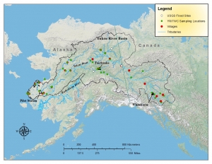
Since 2006 the program has expanded, accumulating an increasing number of water samples and interacting with a growing number of Yukon communities. Beginning with only 20 water-sampling sites in the Alaskan section of the basin, the YRITWC today has sites that continue from the headwaters of the Yukon River near Whitehorse in Yukon Territory, Canada, to the outlet of the Yukon River in Pilot Station, Alaska (see Figure 1). The enormous scale of the YRB presents a unique set of logistical challenges that have been met by the collaborative partnership between the USGS and the YRITWC.
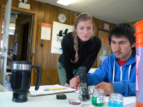
During each field season since 2009 approximately 200 samples have been collected from roughly 40 sampling locations. Samples from seven to fifteen of these sites are collected by YRITWC staff—depending on levels of community participation, funding, and other support. Community members collect all other samples (see Figure 2). Community members participating in the water-quality program in Alaska are often Tribal Environmental Coordinators funded through the Environmental Protection Agency's Indian General Assistance Program. In Canada, participating community members typically work for the Lands and Resources department of their First Nation government. Water-quality field measurements include pH, specific conductance (a measure of the total ion load of the water), water temperature, and dissolved oxygen content—in addition to the collection and processing of a suite of water samples for laboratory analyses by the USGS. The YRITWC staff in Fairbanks, Alaska and Whitehorse, Yukon Territory, coordinate sample shipment from the communities and complete post-processing of the samples. The water-quality samples are then shipped to the USGS National Research Program laboratories in Boulder, Colorado where they are analyzed for dissolved organic carbon, greenhouse gases including carbon dioxide and methane, major ions, nitrogen species and phosphate, trace metals, and water isotopes.
Real Results
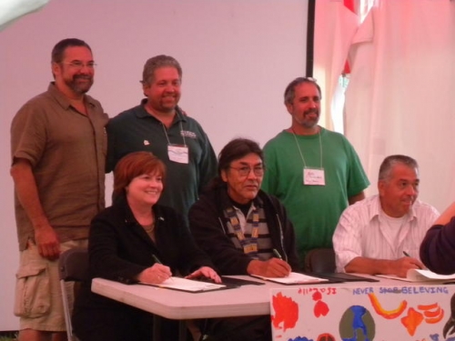
The USGS-YRITWC partnership has yielded six years of data collection thus far, adding to existing USGS datasets. This joint effort has resulted in a nearly continuous dataset since 1979 at some sampling locations and is augmenting hydrologic information collected at USGS fixed stations (see Figure 1). The USGS and YRITWC jointly published a USGS Open-File Report with data from all samples collected from 2006-2008 and plan to publish data from 2009-2012. In 2009 a Memorandum of Understanding (MOU) was signed by the acting director of the USGS and YRITWC board members reinforcing the partnership with renewal expected at the 2013 biennial YRITWC summit meeting (see Figure 3).

New Partnerships on the Horizon
Based on the success of the USGS-YRITWC community-based water-quality monitoring program, USGS scientists are embarking on a new collaboration with an Indigenous nonprofit organization in the design, training, and implementation of a water-quality monitoring program. The Kuskokwim River Watershed Council (KRWC) was founded in 2005 when a Watershed Summit was held for people from across the river basin. At the summit, community members spoke of their concern for the health of the river. The Kuskokwim watershed is located in southwest Alaska, situated south of the Yukon River, and covers 58,000 square miles.
Much like the YRITWC in 2005, the KRWC is interested in designing a community-based water-quality monitoring program built around the concerns of community members. However, in addition to general contamination and climate change concerns, the impetus of this program is an increasing concern in water-quality as mining interests move into the Kuskokwim watershed. The KRWC would like to begin collecting baseline data against which to measure any changes in water-quality generated by increased mining activity.
Scientists at the USGS National Research Program (NRP) have applied to the USGS Office of Tribal Relations to secure funding to train community members in the Kuskokwim watershed to collect water-quality field measurements and assist the KRWC in designing their water-quality monitoring program. This program will begin with instantaneous measurements of physical and chemical water properties made by community members co-located with USGS fixed stations on the Kuskokwim River (see Figure 1) and sites of community concern on the river. In the future the KRWC may expand into sample collection for laboratory analysis. In addition to water-quality monitoring, the KRWC is interested in assessing invasive species in their area. NRP scientists are collaborating with scientists from the USGS Alaska Science Center in designing a community-based invasive species protocol that will fit the needs of the KRWC. If funding is secured from the USGS Office of Tribal Relations, NRP and Alaska Science Center scientists will travel to two Kuskokwim watershed communities to train community members and KRWC staff in field water-quality measurements, sample collection, and invasive species monitoring.
Summary
The unique partnership between the USGS and the YRITWC provides mutual benefits by fostering outreach efforts that have been essential for community empowerment and by generating scientific data for prohibitively large and remote regions that would be challenging for USGS scientists to sample as robustly alone. The addition of a new partnership with the KRWC to create a community-based monitoring program will only increase these benefits by growing the spatial extent of data collection and empowering more people to take charge of important science in their own backyard.
More information about this project is available here or by contacting Nicole Herman-Mercer (nhmercer [at] usgs.gov).

