The 2014 Sea Ice Outlook (SIO) Post-Season Report was developed by the SIO Action Team, led by Julienne Stroeve, with input from the Sea Ice Prediction Network (SIPN) Leadership Team and with feedback following circulation of the draft report to the SIPN mailing list.
INTRODUCTION
We appreciate the contributions by all participants and reviewers in 2014. The SIPN Sea Ice Outlook (SIO), a contribution to the Study of Environmental Arctic Change (SEARCH), provides a forum for researchers to contribute their understanding of the state and evolution of Arctic sea ice and for the community to jointly assess a range of factors that contribute to arctic summer sea ice minima. The SIO is not a formal forecast, nor is it intended as a replacement for existing efforts or centers with operational responsibility. Additional background material about the Outlook effort can be found on the background page. With funding support from a number of agencies, the SIPN project provides additional resources and a forum for discussion and synthesis. This year we received a total of 88 submissions from June to August, with 28 individual submissions focused on pan-Arctic conditions for June and July, and 24 for August. We had also 1 regional submission in June, 3 in July, and 5 in August.
PAN-ARCTIC OVERVIEW
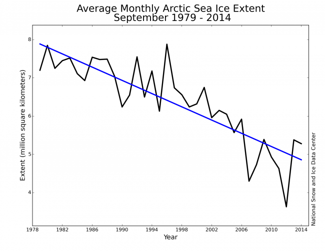
The sea ice monthly extent for September 2014 was 5.28 million square kilometers, based on National Snow and Ice Data Center (NSIDC) estimates using the NASA Team sea ice algorithm (http://nsidc.org/data/seaice_index), which is 100,000 square kilometers below the value for last year, making it the 6th lowest extent on record (Figure 1). This number represents a monthly average and is dependent on a particular passive microwave algorithm to derive ice concentration (see the CliC Arctic Sea Ice Working Group note on the accuracy of satellite-derived passive microwave estimates of sea ice extent; www.climate-cryosphere.org). For example, using the Bootstrap algorithm, the ice extent in 2014 was 100,000 square kilometers higher than in 2013 (5.49 vs. 5.39 million square kilometers). Data from NSIDC's MASIE (http://nsidc.org/data/masie) also suggests 2014 had a higher mean September extent, giving a monthly mean of 5.08 million square kilometers in 2013 compared to 5.37 in 2014 million square kilometers in 2014.
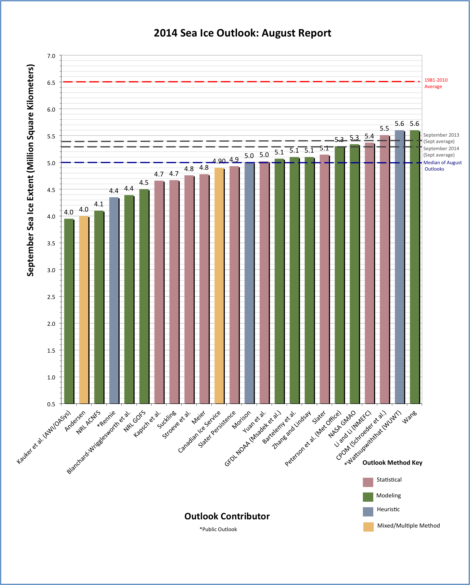
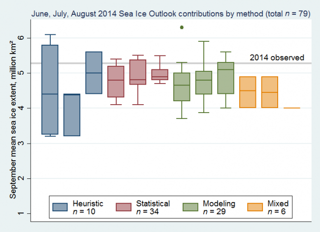
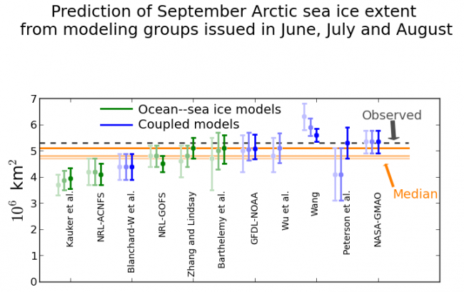
Based on 24 pan-Arctic contributions submitted in August, the median Outlook value for September was 5.0 million square kilometers with quartiles of 4.6 and 5.2 million square kilometers (Figure 2). The median value was higher than both the June and July submissions by 0.3 and 0.2 million square kilometers, respectively, and within 0.3 million square kilometers from the observed value. This bias was less than that in the 2009, 2012 and 2013 SIO submissions, but larger than observed in the 2008, 2010 and 2011 submissions. Four submissions were above the observed mean extent of 5.3 million square kilometers, and two submissions matched the observed value. The linear trend from 1979 to 2014 would have put 2014 at 4.7 million square kilometers.

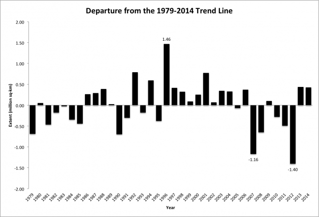
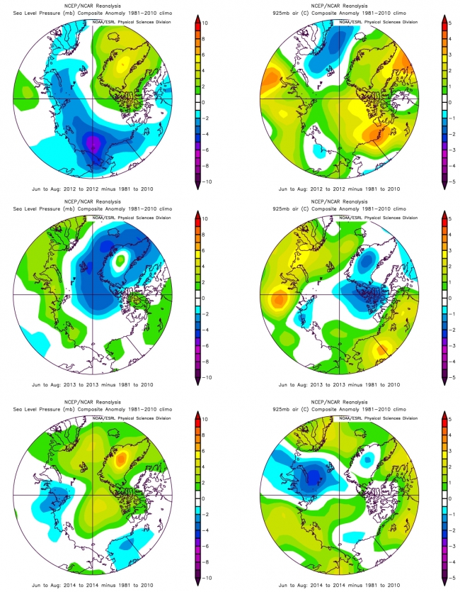
While extent in 2012 was 1.40x10⁶ km2 below the trend line, both 2013 and 2014 ended up within 0.50x10⁶ km2 of the trend line (Figure 4). The atmospheric circulation pattern during summer 2012 featured negative pressure anomalies centered over the East Siberian and Chukchi seas coupled with positive anomalies over Greenland. This resulted in positive temperatures anomalies at the 925 hPa level over most of the Arctic Ocean, peaking over the Beaufort Sea where the sea level pressure (SLP) anomaly pattern favored strong southerly winds that helped to bring in warm air from the south (Figure 5). Summer 2013, on the other hand, saw mostly negative SLP anomalies over the Atlantic sector of the Arctic and north of Greenland towards the Pole together with positive SLP anomalies over Eurasia. This pattern favored ice divergence, helping to maintain a higher ice extent in 2013. 925 hPa temperatures were lower than normal north of Greenland and within the Canadian Archipelago.
This summer, atmospheric conditions featured anomalously high SLP over the central Arctic and the Atlantic sector (including Greenland) together with negative SLP anomalies in the Kara Sea. This resulted in colder than normal conditions in the Kara Sea (and a more extensive ice cover than in recent years), and mostly near normal air temperatures over the rest of the sea ice regions. We speculate that in the absence of a summer circulation pattern distinctly favoring ice loss, such as we had in 2007 or 2012, the extent will tend to stay near the linear trend line.
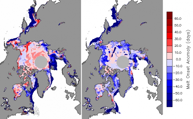
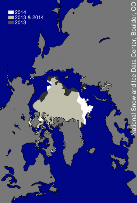
On the Eurasian sector of the Arctic, melt in 2014 began earlier than normal in the Laptev Sea but contained a mix of positive and negative anomalies for other regions (Figure 6). Compared to 2013, melt onset was earlier than normal for almost all regions except the Barents Sea. Atmospheric circulation from July through August fostered cooler temperatures over both the Barents and Kara Seas (Figure 5) that contributed to slightly heavier ice conditions than observed in 2013 (Figure 7). The Laptev Sea ice edge in 2014 retreated to its most northerly position ever observed over the satellite record. The retreat was likely driven by atmospherically induced winds from the south in July through August that pushed seasonal ice in the Laptev Sea northward coupled with weaker winds and thicker ice to the east. The Northern Sea Route was open along the East Siberian Sea coast, although a small amount of ice was present near the coast of Siberia.
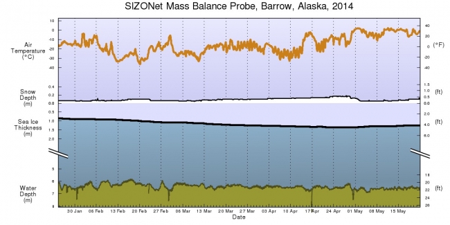
For the North American sector of the Arctic, melt in 2014 began earlier than normal, particularly in Baffin Bay and the Beaufort and Chukchi seas (though with a hiatus in early- to mid-melt and lower sea surface temperatures in the latter two), but later than normal in the northern Canadian Arctic Archipelago. Early melt onset is supported by mass balance observations near Barrow, Alaska (Figure 8). Between April 28 and May 2 almost the entire snow cover melted off the ice. As a result, there was substantial input of solar heat into the ice interior and adjacent leads which in turn led to anomalously early and sustained bottom melt. These mass balance observations at Barrow nicely complement the melt onset estimates from passive microwave and illustrates the importance of integrating satellite data and ground-based observations.
The weak high sea level pressure over the Beaufort Sea resulted in advection of ice toward the Chukchi Sea although the majority of it melted while in transit. This contributed to less ice in the Beaufort Sea in 2014 compared to 2013. Final major sea ice loss in the Beaufort Sea occurred in early September. As there was little time remaining for the newly sea ice free ocean to absorb much solar heating, sea ice in this area rapidly advanced near the end of September. Ocean temperatures in 2014 never reached the positive extremes seen in 2011 and 2012. Northerly winds persisted over the Canadian Arctic Archipelago from June through August keeping temperatures near normal (Figure 5) and contributing to slightly less ice in 2014 compared to 2013. The Northwest Passage remained closed in 2014 as it was in 2013.
REGIONAL CONTRIBUTIONS
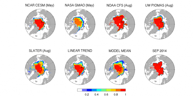
Five groups submitted regional sea ice probability (SIP) outlooks, while three groups submitted regional ice-free date (IFD) outlooks. We focus here on the SIP outlooks, given the greater number of submissions and the fact that IFD patterns tend to reflect SIP patterns (larger SIPs tend to correlate with later IFDs). Figure 9 shows the SIP for all 5 models, the SIP from a statistical forecast obtained by extending the 1979-2013 linear trend at each grid point, the SIP for the multi-model mean ensemble, and the September 2014 extent.
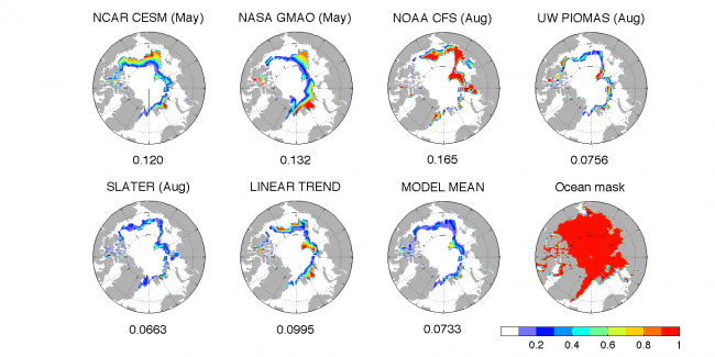
Models capture the observed variability of the sea ice edge with varying degrees of skill. For example, NOAA CFS shows contrasting low and high ice extent in the Laptev/East Siberian seas, yet in both regions sea ice is biased high relative to observations, while NASA GMAO simulates a more uniform sea ice edge and does not capture the low/high contrast across the Laptev/East Siberian seas. The Slater 50-day statistical model SIP and UW-PIOMAS are particularly good in matching observed ice distribution. The linear trend SIP provides a reasonable outlook for 2014, which is not surprising given that total September 2014 sea ice extent was close to the long-term linear trend. We have assessed the skill of the spatial SIP outlooks by measuring the Brier score (Figure 10), and found that the Slater outlook provides the best skill, followed by the multi-model and PIOMAS outlooks. The difference in skill between the best and worst models is a factor of 2, although it is necessary to remember that the initialization dates are different - the Slater, PIOMAS and NOAA CFS outlooks are derived from August initializations, whereas the NCAR CESM and NASA GMAO are derived from May initializations, and so one would expect initializations closer to September to show better skill. Nevertheless, it is noteworthy that no dynamical model simulation beats the statistical forecast of Slater, and that the multi-model mean yields a more skillful outlook than any of the individual dynamical models, a common feature seen in other climate system forecast ensembles.
SUMMARY OF MODELING CONTRIBUTIONS
About one third of this year's contributions were issued using climate models. While much more demanding than statistical and heuristic approaches in terms of design and computational costs, these models are entirely based on physical, dynamical equations and therefore simulate the essential processes that govern the evolution of sea ice at the seasonal timescale. They have the advantage to account for nonlinearities in the system, as well to provide a detailed set of diagnostics relevant for a wide class of users.
Three sources of uncertainty dominate when models are used in the framework of seasonal sea ice prediction: the unpredictable evolution of the atmosphere (and to a lesser degree ocean and sea ice), imperfect initial conditions, and model biases and uncertainties.
The first uncertainty is inherent to the chaotic nature of the atmosphere and is usually estimated by running large ensemble of coupled simulations in which small initial perturbations are introduced. Some groups ran ocean—sea ice models (without interactive atmosphere, the green bars in Figure 11) and estimated this type of uncertainty by prescribing atmospheric conditions from several previous years.
The second source of uncertainty, arising from incomplete knowledge of initial conditions has little been explored this year: only one group (GFDL-NOAA) investigated the sensitivity of their prediction to the initial oceanic and sea ice states.
Finally, each model exhibits its own systematic biases and sources of uncertainty due to discretization errors, unresolved processes or incorrect physics. It is by looking at the spread between all model contributions that this uncertainty can be estimated, since none of the groups performed a suite of experiments where the level of physics, parameter values or the resolution were varied.
It can be seen from Figure 10 that uncertainty is reduced both at the individual model level (the error bars for a given model tend to narrow) and at the multi-model level when the predictions are issued later in the year. In addition, it is encouraging to note that the observed September extent remains bracketed by the multi-model ensemble at all forecast times. Furthermore, the multi-model median prediction, accounting for the compensation of individual model errors, is remarkably close to the observed extent. This in part motivates the multi-model approach.
Whether these conclusions hold only for the particular year of 2014, or are generally valid even when the observed sea ice extent departs significantly from the trend line, has still to be established. We appreciate the effort of all the groups to use a relatively large number of members (all contributions but one use more than 10 members, three use 20 or more). As a recommendation for next year, we encourage the contributors to also examine in greater detail the impact of uncertain initial conditions, including sea ice thickness, on the predicted September extent. This will likely enlarge the individual error bars, but reflect more accurately the uncertainty around each prediction.
DISCUSSION AND LESSONS FROM 2014
To put the SIO performance into context, we summarize here briefly the state-of-the-art knowledge about sea ice predictability. The first source of predictability of a climate variable arises from the persistence of this same climate variable. Characteristic persistence timescales of the sea ice concentration and thickness range from 3 to 7 weeks and from a few months to a few years, respectively, whereas the pan-Arctic sea ice extent/area and volume exhibit a persistence of 2 to 5 months and 4 to 10 years respectively, with a larger persistence in summer. This contributes to the particularly good performance of statistical forecasts relative to dynamical forecasts for very short lead-times (1-2 months). The reemergence mechanism from the growth to the melt season which relies on the persistence of sea ice thickness anomalies could provide additional predictability for the September Arctic sea ice extent: a positive (negative) sea ice area anomaly in the growth season is associated with an early (late) date of freeze up, locally creating a positive (negative) sea ice thickness anomaly that slows down (accelerates) the sea ice retreat during the next spring and is therefore associated with a local positive (negative) sea ice area anomaly during summer. The same argument can be made for melt onset anomalies discussed above; potentially these can have a greater impact even through positive feedback through albedo, whereas freeze-up onset is dampened by negative feedbacks for earlier thick ice.
The winter preconditioning of the summer Arctic sea ice extent by the memory of the sea ice thickness distribution could also provide additional predictability over simple persistence: whereas the thinnest ice melts during spring and summer, thick ice persists until the end of the summer so that the spring area of thick ice stands as a better predictor than the total Arctic sea ice area for the September Arctic sea ice area.
Further predictability can be provided by the ocean's long memory: the Atlantic Ocean heat transport has been highlighted as a key driver of the sea ice edge interannual variability in the Atlantic Sector; the warm water inflow through the Bering Strait has also been suggested to explain about one-third of the 2007 sea ice melt. Other sources of predictability than persistence are not accounted for by statistical forecast systems, which make it impossible for them to have skill beyond the persistence timescales. The various sea ice predictability sources suggest promising seasonal to interannual predictions of the Arctic sea ice conditions. Potential predictability studies estimated the predictability limits of the Arctic sea ice cover using the perfect model approach where ensemble pseudo-predictions are initialized from a reference simulation after slightly perturbing the state selected from this reference simulation. The distance between each realization of an ensemble pseudo-prediction and the reference simulation allows us to quantify to what extent the climate signals in the reference simulation would be potentially predictable with an operational forecast system, if the simulated processes matched perfectly the observed ones. The potential predictability of the total Arctic sea ice area was estimated to be continuously significant for 2 years and intermittent until 4 years ahead. This potential predictability is reduced though, when initializing in May rather than January or July. A higher potential predictability has also been obtained in the Atlantic Marginal Ice Zone (MIZ) than in the Pacific MIZ. Despite the various sources of sea ice predictability highlighted in literature, attempts at operational seasonal Arctic sea ice predictions within the framework of the SIO show substantially worse performance than those suggested by perfect model studies.
Over all 7 SIO years, 2008-2014, the ensemble median SIO prediction now has a root mean square error (RMSE) of 0.73 million km2. For context, we compare this to the RMSE of three reference forecasts: the climatological mean, the linear trend, and anomaly persistence; all three are calculated from 1979 up to but not including the predicted year. The RMSE of the SIO ensemble is considerably lower than that of the climatological mean (1.82 million km2), but only slightly lower than that of the linear trend (0.76 million km2). At leads of 1 and 2 months, the RMSE of August (0.35 million km2) and July (0.66 million km2) anomaly persistence is lower than all other forecasts. At a lead-time of 3 months, however, the RMSE of June (1.14 million km2) anomaly persistence is higher than both the SIO ensemble and the linear trend. The SIO ensemble clearly outperforms a simple climatology forecast. There is only marginal improvement above a linear trend predictor but we expect the main reason for this is the proximity of the 2013 and 2014 extents to the trend line - up to and including 2012, the skill score of SIO with respect to the linear trend had much better values of around 0.5. In other words, in 2013 and 2014 it was much harder to beat a linear-trend forecast, therefore the skill went down. In the future, we expect overall skill to increase compared to a linear trend forecast as more unusual years occur. There was no improvement over persistence at leads of 1 and 2 months. While persistence may prove difficult to beat at 1 to 2 month lead times, for true seasonal forecasts (3+ months lead times) we are showing a significant improvement in skill over persistence.
RECOMMENDATIONS TO IMPROVE FORECASTS
Below we list several suggestions to help improve forecasts:
- Better initialization of sea ice conditions, i.e., incorporating more observational data in the sea ice and the ocean models with consistent ocean and sea ice states;
- Tailored anomaly initialization methods to minimize the drift that would account for the bounded nature of the sea ice variables;
- More advanced model physics (melt ponds, surface scheme in general);
- Ensemble generation methods that better account for initial condition uncertainties and model physics uncertainties;
- Encourage groups to provide information on what they consider as the greatest source of uncertainty in their simulations.
An earlier draft of the 2014 SIO Post-Season Report was posted on 24 November 2014 with a call for input to the SIPN Mailing List.
Citation: Sea Ice Prediction Network. 2014. Arctic Sea Ice Outlook 2014: Post Season Report. http://www.arcus.org/sipn/sea-ice-outlook/2014/post-season


