
Note: The NSIDC revised the date of the sea ice minimum to 14 September 2008. {more}

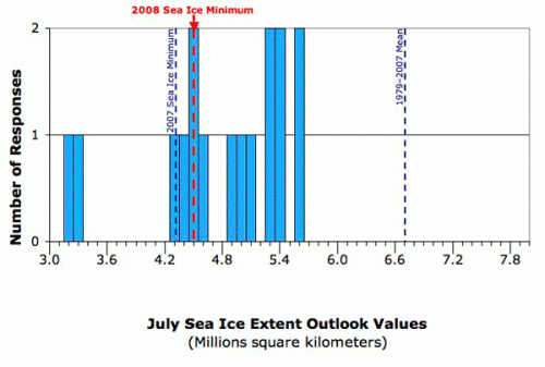
Arctic sea ice reached its 2008 minimum extent on September 12th, at 4.52 million square kilometers (1.74 million square miles), according to preliminary data reported by the National Snow and Ice Data Center (NSIDC). The 2008 minimum represents the second lowest extent recorded since satellite observations began in 1979, slightly greater than the record low minimum of 2007.
The 2008 minimum extent, which is well below the 1979-2007 average minimum of 6.7 million square kilometers, indicates a continuation of the strong downward trend of summer sea ice in the Arctic. The ice cover continues to thin, with less older (multi-year) ice. In addition, for the first time since recorded observations, the ice has retreated away from the coast along the entire perimeter of the Arctic, opening both the Northern Sea Route (Northeast Passage) along the coast of Siberia and the Northwest Passage along the North American coast.

The chart below (Figure 2) shows the observed 2008 sea ice minimum value as compared to the most recent Sea Ice Outlook values (from the July outlook report). The Sea Ice Outlook participants are currently undertaking an analysis of the 2008 season, including an assessment of the factors and processes controlling the sea ice distribution patterns observed this summer, an analysis of the monthly outlooks in comparison to the observed minimum, and an examination of approaches that can improve our predictive capabilities for future efforts. As outlined in detail in the different monthly outlook reports, the effort has provided substantial insight not only into summer ice retreat in the context of a long-term trend, but also into the degree of success and uncertainty associated with different forecast approaches.
Upcoming Sea Ice Outlook Activities:
A series of follow-up activities are planned to complete a thorough retrospective analysis of the 2008 season and to plan for the 2009 Sea Ice Outlook. Please view the Schedule of Activities for more information.
For more information and images related to the 2008 sea ice minimum, visit NSIDC's Sea Ice News & Analysis website and NASA's Images and Animations webpage.